Contact: Prof. Uri Marchaim uri@migal.org.il, Dr. Moshe Meron, Dr. Aviv Ashner
The STARGATE project aspires to develop a breakthrough, multiscale and holistic climate-smart agriculture methodology, capitalizing innovations in the field of microclimate and weather risk management, as well as in the field of landscape design.
STARGATE aims at developing, testing, implementing and showcasing a framework that will improve the resilience of farming systems to variable climatic conditions and extreme weather events, while will deliver scientific sound results to guide policymakers in landscape planning and long-term adaptation of modern agriculture to climate change.
Agriculture is certainly the most weather-dependent economic sector, and changes in the climatic patterns are strongly affecting it, in terms of productivity, risk management, and environmental preservation.
Current farm practices are producing approximately the 25% of the global greenhouse gas emissions, contributing and further enhancing climate change, retaining a continuous cycle of altering the climate and impacting the food production system.
STARGATE will provide innovative components for visualization of big data with a particular emphasis on geospatial visualization and advanced, dynamic charting. MIGAL operate two pilot sites in the Upper Galilee. Project will base on earth observation, weather/climate intelligence and IoT technologies to support a more effective farm management and related options for adaptation on climatic changes, policy formulation leading to better landscape management, protection against climatic risks and implementation related to mitigation on microclimate changes.
The kick-off meeting of STARGATE project took place in Thessaloniki on the 24th and 25th of October 2019 and was coordinated by Professor AUTH and Senior Researcher CERTH Dr Dimitrios Moschou. During the meeting, the importance of reaching a common understanding and establishing an action plan for the following months was highlighted. Furthermore, the full work plan was discussed, the lead of tasks was agreed, as well as the management structure and decision-making mechanisms of the consortium.
The STARGATE project will run for 48 months until September 2023 and involves 26 partners from Greece, Czech Republic, Israel, Spain, Latvia, Switzerland, Austria, Italy, Portugal, Poland, Germany, Norway, and Belgium.
From EU portal:
Objective
STARGATEs contribution beyond state-of-the-art in applied climatic data solutions is the implementation of analytics models to support local and regional policy formulation and implementation related to mitigation on microclimate changes. Currently, policy making organizations predominantly utilize own data, typically limited to their own jurisdiction/administrative area. However, once the policy development process expands the evidence base and data sources beyond the traditional approach, there is need for global data. The addition of national, European and even global reference data sets for comparative analysis — including meteorological, climatic analysis, satellite data sources to improve decision making processes. The studies at landscape scale are required to understand leading ecological processes. The focus will be on Climate Smart Agriculture (CSA) and will extensively study the benefits of applying agri-environment-climate technical solutions to achieve sustainable agricultural development at landscape level. It means to support farm management modernization and at the same time get to know the underlying ecological factors that shape the farming landscape. STARGATE will leverage access to this data and also STARGATE climatic platform including developed models platforms to foster easy and affordable adoption by policy making bodies. The simples approach to decision support in policy development is effective visualization of data. Good visualization supports the policy developers’ in modelling sustainable policies and decisions. Unlike algorithmic simulation and modelling, visualization leaves the actual decision and assessment to a human user and thus provides an extra quality assurance before actual policy decisions are made. STARGATE provides innovative components for visualization of big data with a particular emphasis on geospatial visualization and advanced, dynamic charting.
https://www.stargate-h2020.eu
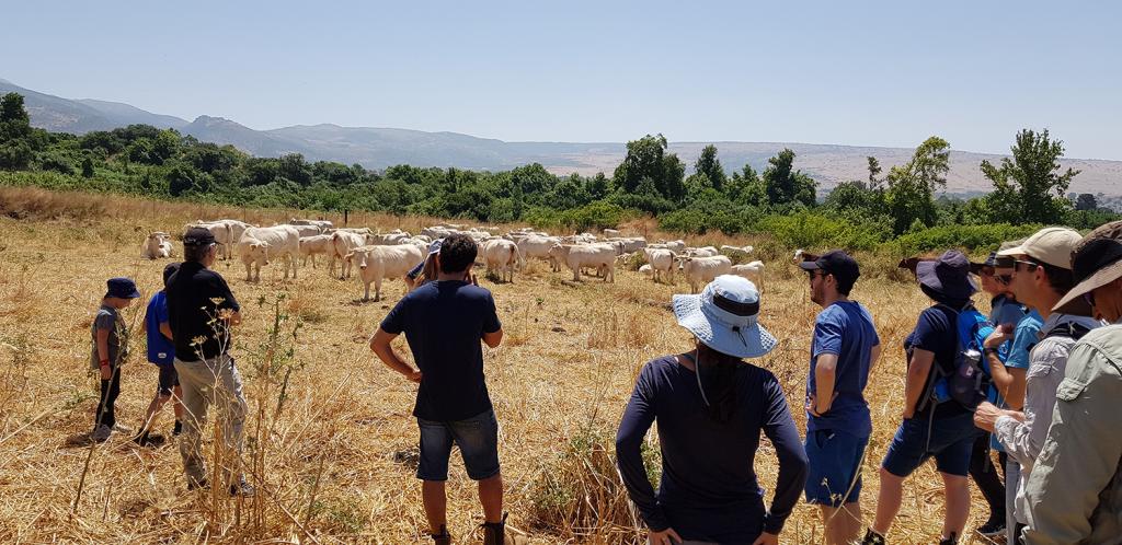
MIGAL STARGATE pilot
1. Cattle Pilot site (Dr Aviv Asher):
Livestock-technology is a system for remotely monitoring grazing beef cows, by field collars mounted on the cow’s neck. We will tracks the cows’ activity 24/7 using an inertial sensor and cow location, and using GPS. A daily summary of the cow's activities (resting, grazing, walking) and location are sent via satellite to herd management system (HMS). The HMS uses scientifically based algorithm to analyse the data collected on an individual cow and herd level.
2. Irrigation pilot site (Dr Moshe Meron):
We will evaluate irrigation uniformity on the field and fruit crops farms in the pilot area, interact with the farmers and evaluate the motivation and economic conditions of the farmers to improve irrigation uniformity and water use efficiency. It will achieve deployment and optimization of remote and proximity sensing instrumentation and methods for crop monitoring and management.
This project has received funding from the European Union's Horizon 2020 research and innovation programme under grant agreement No. 818187.
STARGATE Newsletters: